
Forests are crucial for absorbing carbon dioxide, a major greenhouse gas, helping to slow global warming. The oceans are the primary source of the oxygen we breathe, and both forests and oceans are essential for maintaining the global balance of gases and a stable climate.
It’s important that we can track the health of these ecosystems, because without them we lose one of our most effective natural defences against climate change.
Monitoring forest carbon storage
The BIOMASS mission satellite, the first of its kind, was built in the UK and has supported 250 highly skilled jobs and has brought contracts into the UK worth nearly £77 million.
The satellite will collect data on forest carbon when it comes online in January. It is the first to use P-band radar on an Earth observation satellite, a technology that penetrates deep into vegetation and dry soil. The radar can capture high-resolution 3D images of forests in incredible detail, including boreal, tropical, temperate and mangrove forests, as well as plantations.
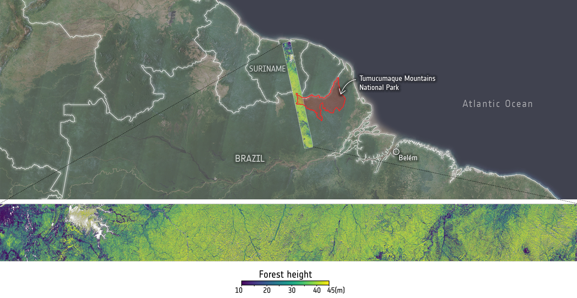
This image shows the height in a section of rainforest that stretches from northern Brazil to Suriname. This capture also includes a corner of the Tumucumaque Mountains National Park. Credit: European Space Agency, DLR, AreSys and Polimi
This specially designed technology will reveal the height of trees and allow scientists to measure forest biomass, about 50% of which is carbon.
It will also provide information on sub-surface structure in dry soils, which can reveal subsurface water sources, and will create the first global map of land surface height under dense vegetation.
This is a critical digital terrain model for accurately mapping and understanding landscapes. The technology can even track the movement of glaciers and ice sheets.
This detail is important because it allows scientists to accurately measure forest biomass and carbon storage, which are critical data for understanding how forests are responding to climate change and for informing global climate policy.
UK investment is protecting our world
Launched from French Guiana in April by the European Space Agency (ESA), the satellite is part of an international collaboration. The mission is co-funded by the Natural Environment Research Council (NERC) through membership of ESA, and has been years in the making.
Louise Heathwaite, Executive Chair of NERC, said:
Forests along with soils are the planet’s most effective terrestrial carbon sinks. However, climate change, especially when combined with human-driven deforestation and degradation, causes the stored carbon in them to be released back into the atmosphere, accelerating global warming.
The BIOMASS mission has received public investment from NERC over many years. Tracking the health of these forests is crucial to addressing climate change and ultimately safeguard the wellbeing of people in the UK and around the world.
The first images
The first striking images from the satellite were released in June. These showed in great detail the vast forests of Bolivia and the Amazon Basin, offering a glimpse into the satellite’s powerful capabilities.
Scientists believe that collecting forest data at this scale for the first time could transform our understanding of forest ecosystems.
Long-term research investment is seeing results
Professor Shaun Quegan, from the National Centre for Earth Observation, was joint proposer of the BIOMASS project with Dr Le Toan of CESBIO, Toulouse, in 2005. Over the last 20 years scientists and engineers have been supported by public investment to develop the mission, building new technology to realise it. The mission encompasses not just the satellite itself but the entire design of observation and data dissemination strategies
Professor Quegan explains:
For 20 years I’ve tried to understand how soil and vegetation affect the earth’s carbon cycle, so I’m deeply interested in how the land surface adds and removes carbon from the atmosphere.
As part of that effort, we conceived the idea of the BIOMASS satellite. The information it provides will give us a much better handle on the role forests play in the global carbon cycle and the two-way flows of carbon between the land and the atmosphere.
Next steps
The satellite is currently undergoing commissioning, a stage in which its onboard systems are tested and calibrated. When it comes online in January, BIOMASS data will immediately become available to scientists via open-source platforms.
Over the coming years, the BIOMASS satellite will gather a vast array of data which will:
- support governments and major carbon-based industries in developing effective climate policies
- make decisions that will build an effective and sustainable economy
- protect jobs
- ensure supply chains are resilient to change caused by climate change
By shaping policies, this project will protect lives and strengthen economies and communities. It represents yet another step in NERC’s 60 years of investment in key research that is finding the solutions to tackle the planet’s biggest challenges.
Find out more about the BIOMASS satellite project.
The satellite monitoring our forests, BIOMASS. Credit: UKRI
Video transcript and on-screen captions are available by watching on YouTube.